Monday, April 30, 2012

Day 183: Nazca to Paracas

Since Nazca doesn't really have a lot to offer besides the lines, I decided to make my way to the coastal village of Paracas today. The bus left around noon, so I had plenty of time to visit the Antonini museum of archeology before.

The museum presents photos and exhibits from a number of excavation sites in the Nazca area. What impressed me most was a surprisingly obvious insight. The Nazca seem to have been masters of pottery, leaving behind beautifully decorated pieces like this:


Now, I had seen items like this before, in the museum of pre-Colombian art in Cusco. What hadn't occurred to me then, however, was that they would have needed special tools to produce the delicate paintings. Due to the arid desert climate around Nazca, some of these tools have been preserved perfectly and are now exhibited in the museum:


1500 year old paintbrushes, looking almost new - how crazy is that?

Day 182: Nazca

The first thing I did when I arrived in Nazca was arrange my overflight of the famous Nazca lines. The flights are ridiculously expensive for Peruvian standards - easily recognizable because they, like all ridiculously expensive things in Peru, are priced in US dollars. But this couldn't be helped, got to see the lines!

At Nazca airport, a host of tiny planes was waiting for tourists. Apparently, Nazca line overflights are the only flights happening here. This is the four-passenger Cessna 206 I flew in:


My travel guide, and also the lady at my hostel, had warned against eating anything heavy before the flight, so I only had some orange juice. But this didn't help: the bumpy flight in combination with tight curves and trying to spot things on the ground made everything come out again.
Maybe I should strike "learn to fly" off my bucket list - seems my stomach can't handle small planes.

Under these conditions, it wasn't all that easy to fully appreciate what I saw. But anyway, the lines and figures are amazing. This monkey, for example, is 110 meters wide. No chance to see this from the ground!


The hummingbird, 96 meters. Look at how perfectly parallel the lines are:


You can also see how the figures are connected to a pattern of straight lines and rectangles. These actually make up the majority of the lines. The figures are pretty small in comparison.


The lines were apparently not etched into the ground. All their creators had to do was clean away the top layer of dust and stones to reveal a lower layer of lighter ground. The dry desert climate then did the rest to preserve the lines.

To get an idea how big the figures are, these two - a tree and hands - have a highway and cars as a size reference:


In the evening, I visited the Maria Reiche planetarium, named after a German scientist who spent 60 years of her life in Peru investigating the lines. The show tried to shed some light on the purpose of the lines. Some theories are: a giant calendar that indicates solstices and stars, a method to point to water sources in the region, and open-air temples. However, there doesn't seem to exist a consensus. And as the lines were made in a period of more than 1000 years, it may even be possible that the purpose changed over time. I love a good riddle, but knowing that the solution might be forever lost is somewhat frustrating, isn't it?

Day 181: Back in Cusco

After the long and exhausting visit to Machu Picchu yesterday, I didn't feel up to much today. So except for sleeping in the morning and boarding a bus to Nazca in the evening, I only managed a visit to Qorikancha in between.

Qorikancha is said to have been the site of Cusco's most splendid temple, full of valuable religious idols and with walls covered in sheets of gold. Naturally, the spaniards couldn't bear such a temple in their conquered city, so they dismantled it and gave the grounds to Dominican monks. These promptly built a church on top and painted the inca walls with colonial patterns.


Out back is a garden decorated with "tired" stones - pieces of inca masonry that have been torn out of their original context and are now stones without walls.


Another exhibit in the museum explained the inca's relationship with the night sky. Apparently, they not only recognized constellations consisting of stars, but also constellations consisting of dark areas. I wonder why we don't do that? This painting shows some of the dark constellations they saw in the milky way, among them a snake, a llama, and a shepherd:

Day 180: Machu Picchu - Inca Jungle Trail (4)

Another early morning: we started hiking towards Machu Picchu at 4: 30 am. After half an hour, we crossed the bridge marking the park entrance. From there, we started climbing the roughly 1600 steps to Machu Picchu, covering 400 meters of altitude difference. For about the last third, it was finally light enough to walk without a flashlight. But when we finally got to the top, tired and covered in sweat, we were richly rewarded by seeing the sun rise over the mountains and slowly illuminate Machu Picchu. What a sight!


The purpose of Machu Picchu is not entirely clear: some say it was a religious site where people made pilgrimages to, others say that the ninth Inca Pachacutec built it as a mansion. In either case, it makes sense that only about 200 handpicked people, mostly priests and nobles, lived permanently in Machu Picchu.

By the way, the word Inca strictly speaking only denominates the ruler of the empire. The ordinary people living in the empire were Quechua, like the language spoken in the empire.


Like in many other Inca places, Machu Picchu also had an intricate irrigation system. Some springs were reserved for religious purposes like ritual baths. Others were used for agriculture, with a system of terraces making sure the available space and water were used optimally. All of the terraces in this picture, now planted with grass, were originally used for crops like corn.


The internal structure of the terraces is also fascinating. They are built following an ingenious layered system of different kinds of stone, sand and soil to ensure that the water flows to the terraces below in just the right way.


Machu Picchu is also fascinating in terms of masonry. They purposely employed stones with many sides to increase the stability of the walls, like this one:


It is also very interesting to see how they distinguished between important (temples) and less important (housing) buildings by varying how well the walls were built. This, for example, is a temple wall. In the back, you can see the decidedly less fine construction used for the terraces:


Machu Picchu also had a sun dial that could indicate important dates in the year, like the times to start planting or harvesting, and the time of the Inca's most important festival, Inti Raymi. This festival was, and still is today, held on June 21st, the year's shortest day. On this day, many many llamas (think thousands) were sacrificed to persuade the sun god Inti to stay.

The construction of Machu Picchu was not undertaken in a haphazard way, but was planned carefully. Models were carved in stone for all aspects, from location to the arrangement of the different sectors and the layout of each sector. This stone, for example, is a model of Machu Picchu and the surrounding mountains and rivers.


The location of Machu Picchu was carefully chosen so that it was surrounded on all sides by higher mountains. These mountains, venerated as gods, were believed to protect the site.

One of these mountains is Huayna Picchu, with its 2700m 300 meters higher than Machu Picchu. Every day, 400 visitors are allowed to make the steep climb up to Huayna Picchu. I had heard great things about the view from up there, so of course I had to go too. And this is Huayna Picchu:


The climb up wasn't too bad, but all stairs again. My rough estimation is that I climbed at least 3000 steps that day (and descended that many again) - think about doing 3000 squats, that might come close ;-) Anyway, the view from the top was breathtaking:


And we could also see the street and stair access ways that lead up to Machu Picchu - looks kinda harmless from up there, doesn't it?


On top of Huayna Picchu, birds and small lizards were feasting on the crumbs left behind by the hungry climbers ;-)


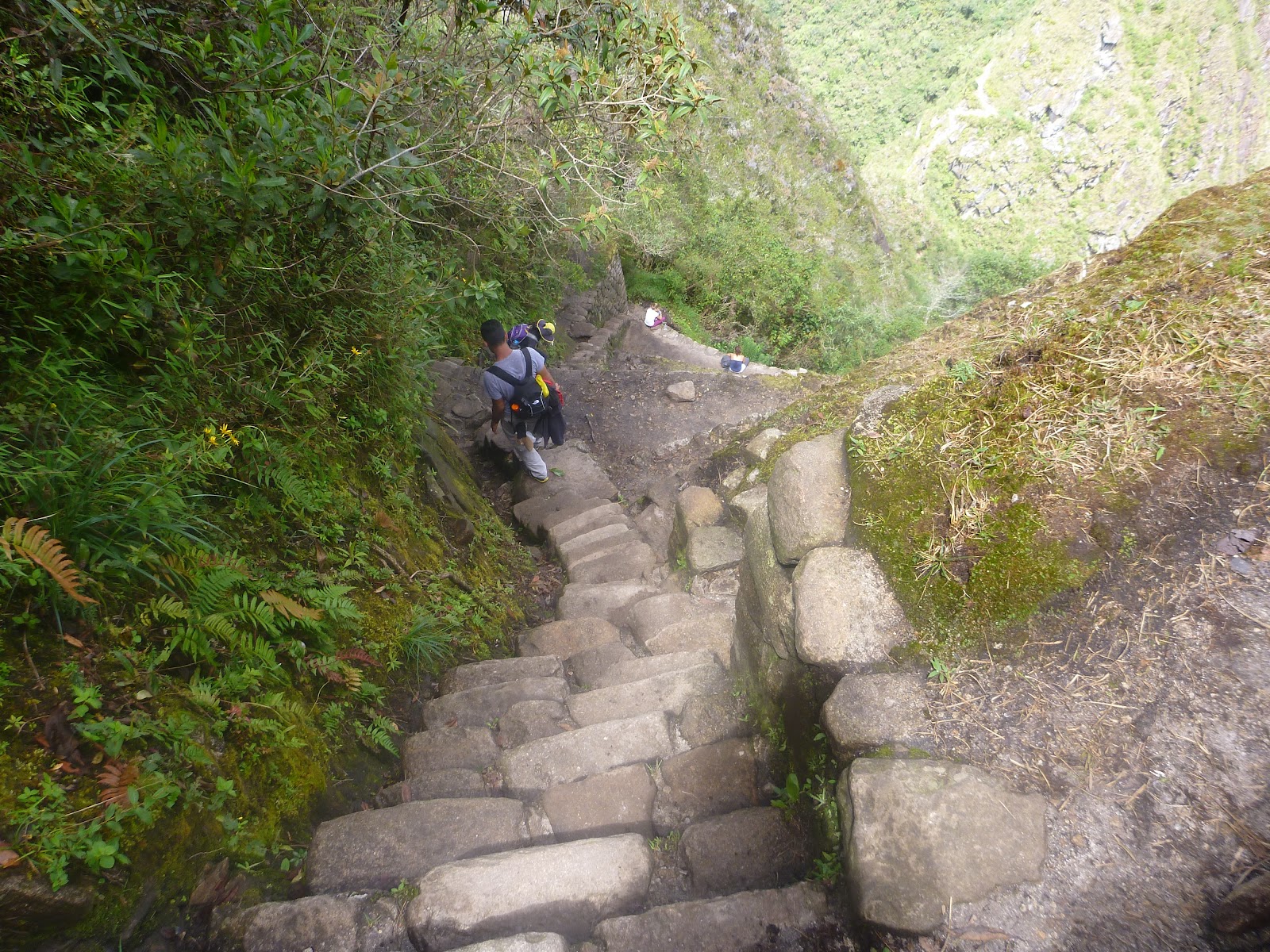
The descent was far worse than the ascent because of the steep and narrow steps. Photos can't really convey the steepness, but I tried to capture it anyway:


After Huayna Picchu, we visited the Inca bridge, a small wooden bridge built into the side of a steep cliff. Looking at the thing, I couldn't help but wonder why they bothered to use wood at all instead of just covering it all with stone.


Finally, I decided to climb up to the sun gate to get a view of Machu Picchu from the other side:


The afternoon rain covered Machu Picchu in clouds, offering delightfully mystic views:


Saturday, April 21, 2012

Day 179: Inca Jungle Trail (3)

The third day of our trek was rather short and relaxing - good preparation for the big fourth day ;-)

Throughout the day, our guide explained some more about Inca culture. After the visit to the high altitude archeology museum in Salta, I had condemned the Inca for sacrificing children. Well, it seems that this wasn't the whole story. The Inca empire started out quite small, covering only the region around Cusco. Only with their ninth ruler Pachacutec they started expanding rapidly. Their conquest wasn't entirely based on a strong military: they convinced other tribes to join in by offering their knowledge and technology, which meant a more reliable food supply, as well as communications and trade throughout the empire. An important bit of their strategy was to let other cultures keep their customs. In the entire empire, sacrifices were made to honor and placate the sun god Inti. The type of these sacrifices, however, depended on what the cultures were doing before becoming part of the Inca empire. Many sacrificed only llamas, while others offered children. In the capital Cusco, for example, no child sacrifices were made, whereas the people in the region of Salta apparently had this custom. This was very interesting news for me - and at the same time a very old insight renewed: oversimplified and generalized judgments lead nowhere because reality is full of complicated, fascinating details. Once understood, these reveal a more differentiated, and often very different, story.

Well, back to the hike itself. Our only task for the day was to circle around the base of Machu Picchu mountain to reach Aguas Calientes, the town from which we would start our ascent to Machu Picchu the next day. From the base of the mountain, we could catch a first glimpse of Machu Picchu pretty early in the day:


Most of the day's hike was along train tracks. I was wondering whether the tracks were still in use or not - locked-down track switches and broken signaling seemed to indicate they weren't. Then, I could suddenly hear a train's horn honking, and soon it appeared from behind the next bend - no doubts left after that:


In the afternoon, it started raining for a bit, leaving behind a bunch of clouds in the river valley that created a very beautiful effect:


Shortly after, we arrived in Aguas Calientes which is a rather nondescript little town. Besides the proximity to Machu Picchu, its only distinguishing feature is the huge, overpriced arts & crafts market right next to the train station. I therefore didn't feel I missed anything by going to bed early ;-)

Day 178: Inca Jungle Trail (2)

The second day started out with the guide painting all of our faces using the mashed seeds of a plant. This is the spider he painted on mine:


We then started our hike and very soon got to walk on a piece of original Inca trail. Apparently, the Inca built around 40.000 km of trails throughout their empire. They also classified the paths according to their widths: the widest ones were used for trade, while the smaller ones were reserved for religious purposes and messengers. See the path built into the mountainside in the left part of the picture? That's where we came down.


This specific part of Inca trail has only been rediscovered 14 years ago. In 1998, there was a massive landslide/avalanche/flood disaster, destroying houses, roads, bridges and the railway in the river valley. As a consequence, the people moved up the mountainside to protect themselves from future events of this sort. When they started building new paths to connect the different communities along the valley, they discovered the Inca path that was already in place there. Only then did the Inca jungle trek become popular, providing the people with tourism-based income.

The vegetation continued to be nice and colorful, and there were butterflies around us all day.


As the guide explained, there are minor landslides in the area every year, so that the path always changes, and sometimes necessitates a fair bit of improvisation. This makeshift bridge, for example, had to replace the proper one that had recently been washed down:


Another funny bridge we encountered later in the day was this cable-car type one. The ride across definitely was a lot of fun!


The perfect, relaxing end to the day were once again thermal baths. Nothing better to loosen your muscles and wash the hiking grime off your body :-)

Day 177: Inca Jungle Trail (1)

So, this is it, one of the things I've been looking forward to most: the four-day hike to see Machu Picchu. As tickets for the "original" inca trail sell out months in advance, I decided to go for the inca jungle trail. This trek combines mountain biking with hiking through the jungle - a much more agreeable climate than the high mountain route the other trek uses :-)

So we started off at 6 am and drove straight to the pass at Abra Malaga at about 4300m. From there, we cycled down the mostly paved road to about 2000m of altitude. Especially the first part was cold and rainy, and sometimes we had to go straight through clouds. When we stopped to enjoy the view of a valley, it was alternately completely covered in clouds, or partly visible like in this picture:


The rain stopped during the second part of the bike ride, but we weren't yet finished getting wet... As we found out, there were many mountain streams running across the street like this:


And, of course, we had to cross the streams to get to our destination. In the end, all of our hiking boots were completely soaked through. If only they had told us to wear flip flops for the second part!

After lunch, we only had a short uphill hike (in wet boots) left to reach the family farm we would spend the night at. The main source of income for people in this area is coffee. We passed one farm that was in the middle of a coffee harvest. What they do is they collect the coffee fruits off the bushes and gather them in a big tank:


There they remove the peel from the fruits and wash the remaining seeds - the coffee beans. These are then laid out in a courtyard to let them dry for three days. In this courtyard, there are about 20 kilos of beans:


After drying, they can be sold to a company who does classification, roasting and grinding. One kilo of dried coffee beans goes for about 4 Soles - a little more than 1 euro.

Another source of income are dried coca leaves. The price is controlled by the state, so that the contents of one coca field, about 12 to 13 kilos, can be sold for 70 Soles. That is 20 euros per coca field, which can be harvested every four months. If you consider these numbers, it is no small wonder that narco-trafficking is booming.

On a more positive note, the lush jungle landscape was fantastic again. These pink flowers, for example, are all over the place:

Day 176: Inca Ruins

Today I was joined by a Welsh guy and an American girl for a little hike to a bunch of Inca ruins just outside of Cusco. Everyone recommended catching a bus to the top and then hiking back down to Cusco - we did it in reverse. Since the furthest ruin is only 11 km from Cusco, and about 400m higher, the walk wasn't too exhausting.

The first ruin, Sacsayhuaman, was the biggest of the four, so we got a guide to show us around. Apparently, it was a religious site, not a fortress as the Spanish had initially believed. But then again, all the Inca towns seem to have had strong fortress-like walls so they could be used like one in case of emergency. Sacsayhuaman was then used as a quarry for the construction is Cusco's cathedral, so today only those parts of the walls remain whose stones were too big to be moved by the Spanish. This is the second biggest stone:


It was part of this zig zag wall:


Behind the wall: the temple. In front of it: a huge plaza where all ceremonies were conducted. Our guide explained that the temple was used only as storage for religious idols and stuff, and that ceremonies always took place outdoors.

On the other side of the plaza was a huge slab of volcanic stone. Apparently the Inca believed it to be sacred and thus built a wall around to protect it.


Another piece of evidence that the Inca were incredibly skilled masons: this perfect doorway.


About ten minutes from Sacsayhuaman, we found the next ruin: Q'enqo. They had a nice little labyrinth and this huge monolith standing at the end:


The two remaining sites were about an hour's walk away. Tambomachay seems to have been the Inca equivalent of a spa, and apparently the rulers' favorite resting place.


Just across the road, Puka Pukara served as a fortress protecting both the spa and, perhaps more importantly, the road that led into the Inca capital Cusco.


Back in Cusco, we found a nice Indian restaurant to warm up again - the winds at the top had definitely been chilling ;-)

Friday, April 20, 2012

Day 175: Cusco Museums

I decided to dedicate this day to some of Cusco's museums. My first stop: the Inca museum. Sadly, the museum isn't all that great. In some sections, there are too many exhibits, in others too few, and in general there were never enough in-depth explanations given. Especially the last part makes a little bit of sense once you know that they are trying get people to do a nominally-free-but-tip-expected guided tour. Well, not all museums can be top notch.

The next museum, however, definitely was. The museum of pre-Colombian art has a range of exhibits grouped by culture, mostly pre-inca, some going back about 3000 years. I liked pretty much everything about the museum: the rooms, the presentation of the exhibits, the detailed explanations given, and of course the wonderful exhibits themselves.

Most of the pieces in the museum were ceramics - but not the crude kind you often get to see in archeological museums. Instead, these were elegant bottles, vases and plates, tastefully adorned, and definitely deserving their place in an art museum. For example, look at this vase with colorful birds painted all around:


The perfectly round shapes were achieved without any help from a rotating plate. Amazing, isn't it?

Two of my favorite pieces in the museum were these bottles in the form of ducks:


From their appearance, I wouldn't have guessed that they are hundreds of years old - they could just as well have been designed only yesterday.

On my way to the next place, I found an excellent example of how many of Cusco's modern buildings rest on Inca foundations:


Santo Domingo church is another place where the Spanish tore down an Inca palace and built a church on top to demonstrate their domination. Interestingly enough, the church itself has been damaged by earthquakes several times, but the Inca foundations never showed any sign of damage. The reason for this is probably the anti-seismic manner of construction the Inca employed: blocks of stone fit on each other perfectly, and all the walls are slanted inwards slightly.


My final stop for the day was the chocolate museum. The smell alone in the museum was incredibly irresistible, inviting to an extended stay ;-) I learned that the Maya in central America discovered the process of how to produce chocolate from cocoa fruits. The process is quite involved: you have to ferment the seeds, dry them, peel away the shells, roast the nibs inside and finally grind them and add hot water and spices to obtain a delicious chocolate drink.

Peru is relatively new to large-scale cocoa export, but growing rapidly. To get farmers away from cocaine production, the government set up an interesting initiative: it encourages farmers to replace coca plantations with cocoa plantations. The museum reported good initial success - but I guess only time will tell if chocolate is as appealing as cocaine ;-)